ENEON services
ENEON is the instrument that will bring together networks involved in research and innovation relevant to GEOSS, with a particular focus on the in-situ segment. The observation inventory based on GEOSS GCI Information, GEOSS DAB, and Copernicus services catalogues allows to assess the coherency, continuity, accuracy and accessibility of the information available, and thus providing more accurate forecasts and projections. From a technical point of view, the review of the GEOSS DAB will ensure that all the networks are contributing valuable resources to GEOSS. ENEON also addresses emerging European networks and sensor development projects to provide future provisions which may not yet be part of GEOSS or Copernicus Services. This inventory is connected to the URR-2.0 allowing the immediate applicability of the observations in forecasting and projections.
ENEON code Github repository
The site explains how to apply the graph used in www.eneon.net for visualizing a graph in the browser read directly from a json file. There are two possible graphs: the first one (graph-EV-SDG) doesn't include queries to the json file, while the second option (graph-vis), does.
Access to ENEON github: https://github.com/grumets/eneon-graph
Mapping of European EO in-situ networks
More information: Mapping European in-situ networks landscape presentation (*.pdf)
Mapping the in-situ networks at the European level has lead to the discovery of a large, complex and incomplete system. In addition, there are different semantics using the word “Network”:
· ObservationSystem is a network that is building some sensor network and collecting data with them.
· SystemOfSystems is a network that has the objective of integrating “ObservationSystems” in a bigger structure.
· Infrastructure is an “informatics” system that connects data, services and sensors to facilitate access to or processing of data.
· DataCenter is a data repository that is not really a network but needs a network to exist. It generally does not own the data but aggregates it in a single repository (in opposition to a system of systems that has a federated structure). Actually it could be argued that this category is out of scope of the ENEON but there are cases where if not included the complete picture is not understood (e.g. the WMO thematic data centers).
· Program is a network created/financed directly by the decision makers that is neither an observing system nor an infrastructure but e.g. a coordination effort.
· Network is anything that cannot be classified in the previous categories.
· NetworkOfNetworks is a network connected to other networks with the intention to aggregate them.
The applied model is based on LTER Network Metadata Model (NMM) but enriched adding the necessary relations between networks, the financing projects, and the link with SBA and GEOSS. In this model, each individual network is defined by a reduced set of properties including links to other networks and specifying the role of this relation.
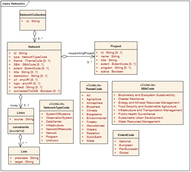
The mapping implementation (the "ENEON graph") has been done using a JSON-LD file which encodes de model and that can be dynamically converted into RDF, whereas the representation is based on an open source code available at GitHub called d3-process-map that uses the d3.js graphical library.
ENEON graph versions
Updated version of the graph on European EO networks incorporating the relation among SDGs indicators, EVs and the EO networks providing content on them. Elaborated under ERA-PLANET GEOEssential H2020 project: http://www.eneon.org/graph-ev-sdg/index.htm.
There's also a version of the graph which includes queries to the database: https://www.eneon.org/graph-vis/index.htm
Previous version of the graph of European EO networks elaborated under the ConnectinGEO H2020 project: www.eneon.net/graph
A WebGIS Client providing access to in-situ measurements
This platform (Initial version) provide access to in-situ measurement available on-line. It is part of the existing webservice-energy SDI (Spatial Data Infrastructure).
The platform enables:
- visualisisation of sensor locations on a map,
- visualisation of measurements as time series as plots and in tabular form,
- display of sensor metadata at different levels of detail,
- computation and statistical representation of time series according to the types of in-situ measurements (eg. solar 2D view, wind roses) and
- download of observation data for offline processing.
It is based on the 52°North SWE (Sensor Web Enablement) solution respecting OGC SOS (Sensor Observation Service) standard and GEOSS recommendation on interoperability.
Link to the webservice: http://www.webservice-energy.org/web-gis-client
Collecting gaps in in-situ EO through ConnectinGEO
ENEON is collecting gaps in EO through the ConnectinGEO gaps table. |
ENEON is asking for gaps discoverability through the following form. |